Wednesday, May 25, 2011

William Abbatt's "The battle of Pell's Point" Photograph Number 5

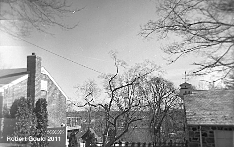
Photograph Number 5 from "The Battle of Pell's Point (or Pelham)"is a view over looking the Hutchinson river valley towards the west. Today the landscape has been greatly altered. Split Rock road now has houses lining both sides of the street. The only way to see the view would be from someones back yard or by catching a glimpse of it between the houses. This is what I have done and the results are not that great. The woods in the distances of the 1901 photograph has been filled in with large shopping malls and parking lots. The Hutchinson Highway also runs across this area. See the modern image below.
A google earth image of the area showing Split Rock Road and the camera angle. I have also highlighted the location of St Paul's Church. With a slight change in angle it would have been seen in 1901 across the valley.
My Holga 120N view looking between the houses along Split Rock Road.

A detail of the above photo showing the ridge line through the tress.

My drawing from the original 1901 image

Tuesday, May 24, 2011

Cannon Tubes

A Dahlgren Boat Howltzer on display at Petersburg Va.
 
One of my side projects has been collecting rubbings from cannon muzzles from the Civil War battlefields that I have been visiting. The following images are from cannons at Petersburg & Gettysburg. Often the cannon tubes that are on the fields today are original cannons that date from the Civil War period. The muzzles are marked in different ways with info about the gun. Generally the information included the manufacture or foundry & the date. Other info might include the weight, how much the tube weighs & a serial number. Today was able to scan the drawings.They make a interesting visual image.
3 inch Ordnance Rifle Petersburg Va.
12 pound Napoleon Petersburg Va.


Painting Studio slides from 1984

I found some slides that I took of myself painting at my parents house. The slides are dated May 1984.It looks like I'm painting some sort of twisted figure teenage angst guy. A self portrait no doubt. This was when I was in my punk rock phase. I was listening to the Swans first EP, early Sonic Youth, WHFS 102.3, DC HarDCore, Flipper & having a great time! 


Saturday, April 30, 2011

Some Random Drawings

This post is a short brake from the W. Abbatt "then and now" photographic project.I have four more to publish three of which are taken around Glover's rock and will be one post.
I have been working on a number of projects in the studio. I would like to get some longer term painting projects finished this summer, taking advantage of  the slow work season. In the mean time I'm posting some quick drawings.
Battle of Brooklyn


Brooklyn forts


Brooklyn battlefield Panorama
I'm still playing with the Ebenezer Creek Imagery

Thursday, April 28, 2011

Abbatt's Photograph number 7 Wolf's Lane

Then and Now 1901- 2011
This is an interesting shot because even thought the two images are taken 100+ years apart, the suburban terrain hasn't changed all that much.You can see that the earthen embankments are about the same, although today there is a retaining wall on the left. It seems to me that the original photograph was taken a little further down the road. Maybe 20 feet or so. My position is on the right corner of Wolf Lane and what today is the Boston Post rd.
Here is a map of the area from about the time that Abbatt wrote his book. It dates from 1896 or so. I have labeled the important roads. The large arrow is the corner location where the Abbatt photograph was made. The direction of view pictured in the photograph is looking down hill to the left along the Boston Post Rd. In the direction of the "Hotel" marked on this map. This map is important because from it we can see that the modern street grid is just starting to be filled out. Old roads from pre-colonial times are serving as a framework upon which the land is being subdivided into smaller plots. New roads then connect the plots together. On this map you can see the individual houses and who owned them.

5x7 Pin hole camera capture with Fuji 100 B&W film

Wednesday, April 27, 2011

Abbatt's Photograph Number 4 Shore Road

 This is Abbatt's map from his 1901 book. It probably deserves a post all it's own. The red arrow approximates the direction of view from his photograph of Shore Rd. and Split Rock Rd. Photo number 4.
This was a tricky shot to line up in modern times. Today Split Rock road & Shore road do not intersect. But the location was established using Abbatt's map.  Knowing  that the modern golf course has replaced old Split Rock road, and using the old rail road bridge as a landmark, I was able to make a connection. The railroad bridge was put in sometime in the late 19th century. It's an ornate iron type affair that Amtrack still runs over today . Now it serves as the entrance to the golf course, but originally it was built for traffic on Split Rock road to pass under the tracks. All of this works out,  assuming that the position of Shore Road hasn't changed in 100+ years.
Photograph from 1900


View from the edge of Shore Rd. towards the railroad bridge in the center. This is now the parking lot for Split Rock Golf course.

Another view about 75 yards closer with a view of the bridge through the trees.

Monday, April 25, 2011

St. Paul's Church East Chester-Photograph 9

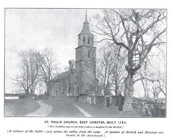
Notice how the old large tree in the lower photo is gone, but the small tree to the left has grown to replace it.

Original photograph from 1900

 
Photograph number 9 Saint Paul’s Church
This was a straight forward now & then shot. Luckily the area has been taken over by the National Park Service when the church closed in the 1970’s. It is wonderful place to visit. There are many activities thought the year, many having to do with the battle of Pell’s Point & John Glover. There is a small museum that is located on the grounds, that feature exhibits based on the history of the surrounding area as well as the historic church grounds. The large cemetery surrounding the church that has an area where British & Hessian soldiers are buried from the battle of Pell’s Point. St. Paul’s was used as a hospital after the battle. Here is the link to their web site.
http://www.nps.gov/sapa/historyculture/index.htm